seeds logo revised 2a
Issue 7
QUANG TRI – A PLENTIFUL PROVINCE
The master plan vision that balances conservation, development, and innovative resilience
LIM SIAH GIM, FENG LUYE
SJ PLANNING
NOVEMBER 2023
Sunset at the river at Dong Ha City, capital of Quang Tri province
Abstract: Quang Tri (QT) is one of the least developed and least populated provinces in Vietnam. As a province with limited financial resources and many critical infrastructures to invest in, the Concept Masterplan (CMP) prioritised the integration and optimisation of investments for economic, urban development and job creation. The approved CMP will act as the basis for the local design institute (LDI) to prepare the actual CMP submission to the Provincial government and Prime Minister for final approval. When approved, the CMP would be the guide for planning and development of the entire province up to 2030. This is accounting for ever-changing socioeconomic needs of the region. The CMP will be reviewed and updated every 5 to 10 years as needed.

BACKGROUND

QT is one of 63 provinces of Vietnam, located within North Central Coastal Region of Vietnam with a population of 638,219 (as of 2020) and a total area of 4,701 sq.km. It is sandwiched between the Quang Binh and Thua Thien Hue province on its north and south, and the Laos People’s Democratic Republic and South China Sea on its west and east. As the east “Bridgehead” of the East -West Economic Corridor (EWEC), QT connects Vietnam to Laos, Thailand and Myanmar. It’s also at the intersection of the EWEC and North-South Economic Axis (NSEA) of Vietnam.
02 Location of Quang Tri in the Region v Large
Location of Quang Tri in the region

Gauging Opportunities and Challenges

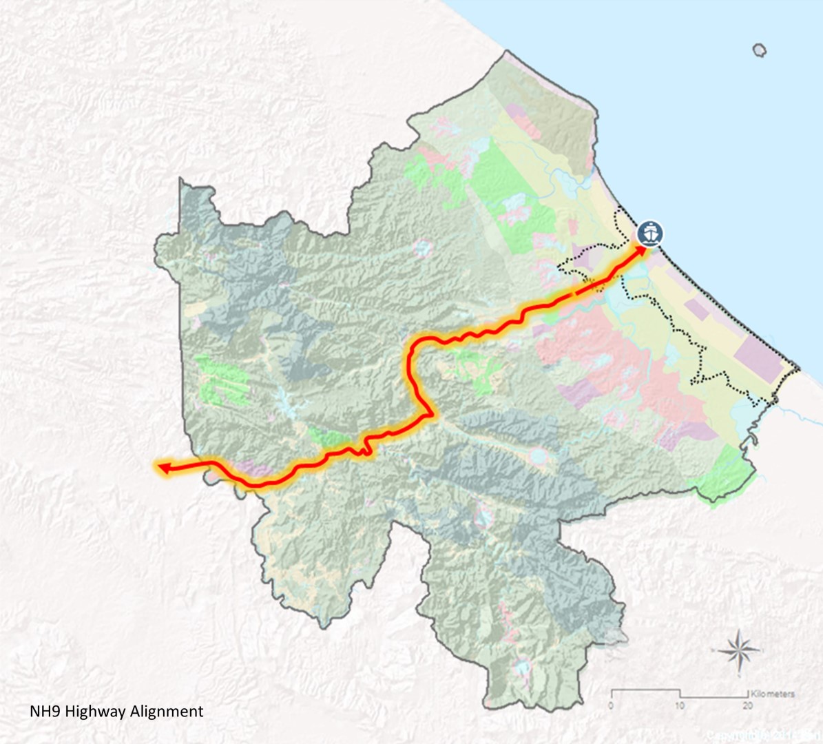
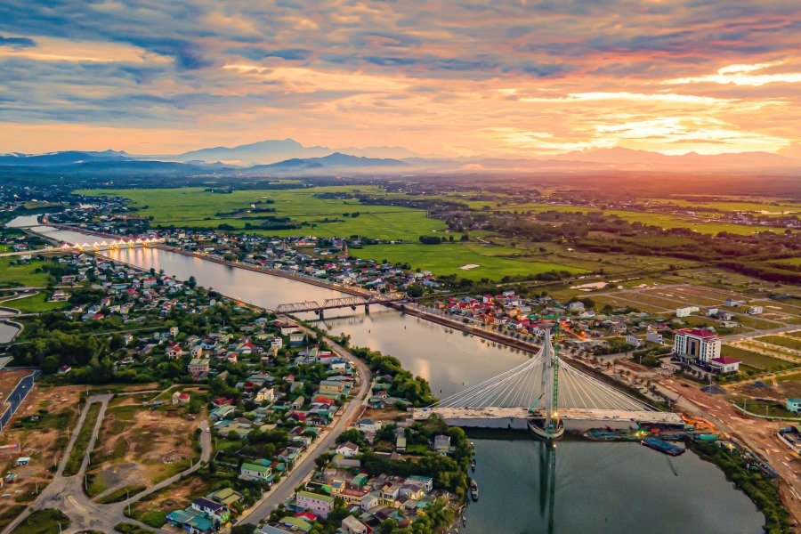
QT’s strategic location at the ‘Bridgehead’ of the EWEC makes it an ideal international marine time seaport, acting as a service centre for the land logged Laos and a large portion of Eastern Thailand. Together with the NSEA, QT is flourishing into a major transportation hub.
QT has diverse topography and ecology, from the bio-riches of the mountainous west to the fertile flood plains in the east. It is a perfect place to transform into a high yield, high tech agricultural hub. QT also 
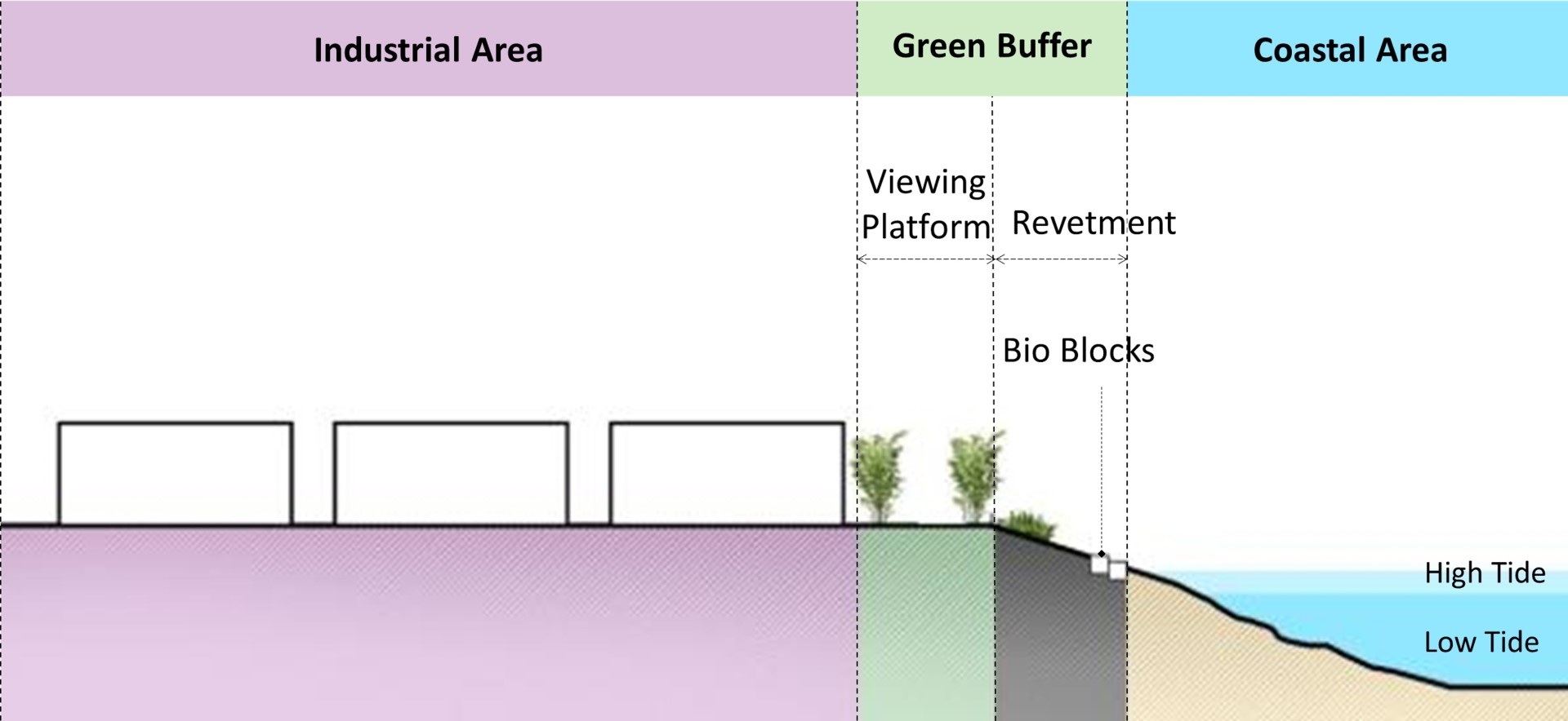
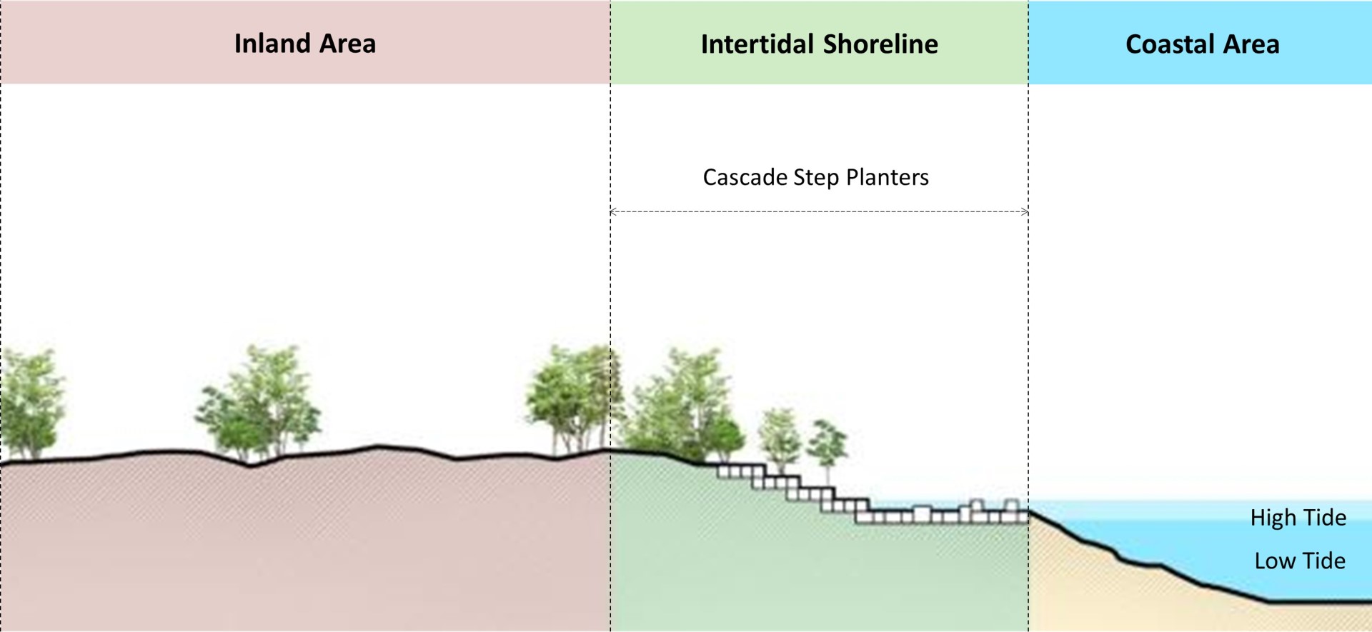
sports a 75km long coastline with beautiful beaches suitable for tourism, along with rich marine fisheries in the adjacent sea. However, due to its geographical location, QT is susceptible to a variety of natural disasters, such as floods, cyclones and landslides. This poses a challenge in protecting both citizens of the region as well as built infrastructure in the area. The infrastructure is also underdeveloped, with lacking critical amenities such as hospitals and institutional infrastructure. Additionally, the current economic activities in the region do not yield high returns in terms of economic value (traditional agriculture, forestry, fishery, etc.). It also lacks a steady stream of tourist footfall, making it one of the poorest provinces in Vietnam. As a result, this has led to brain drain in the region, with talents opting to move to other more developed or developing areas of Vietnam.
01 Khe Sanh Coffee Farm
Coffee farming at Khe Sanh, a coffee-growing region with more than a 100-year history in Quang Tri

VISION

Through interaction with the resilient residents of QT and understanding of QT’s history and goals, we have forged a vision that encompasses the strength of the people and their hopes for the future generation. They desire environmental protection due to its cultural importance, guidance for growth, and an established future promising safety and security. To achieve this, the CMP aims to strike a balance between conservation and development, tapping into the rich natural resources and labour force of the region to drive growth.

QT is envisioned to be a “A Plentiful Province”, enshrining the Vietnamese model of inclusive and sustainable growth, anchored by resilience, innovation and a secure environment, providing boundless opportunities for all.

01 Quang Tri farming
Fish farming in Quang Tri
Planning with foresight and technological advancements at the forefront, the CMP aims to develop QT into a resilient province with potential for endless innovation; one with infrastructure built to shield the area from natural disasters and climate emergencies. It also aims to foster digital transformation through providing incentive for research and development, with a focus on improving crop yields. Combined with efficient and benevolent governance, this paves the way for establishing a safe and liveable environment with a better future for all.

BASE MAP

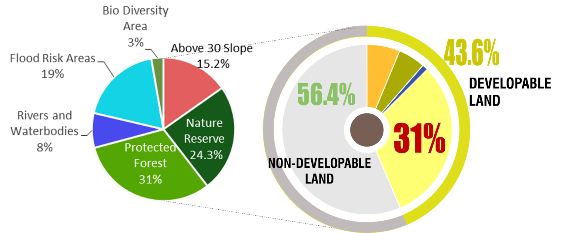
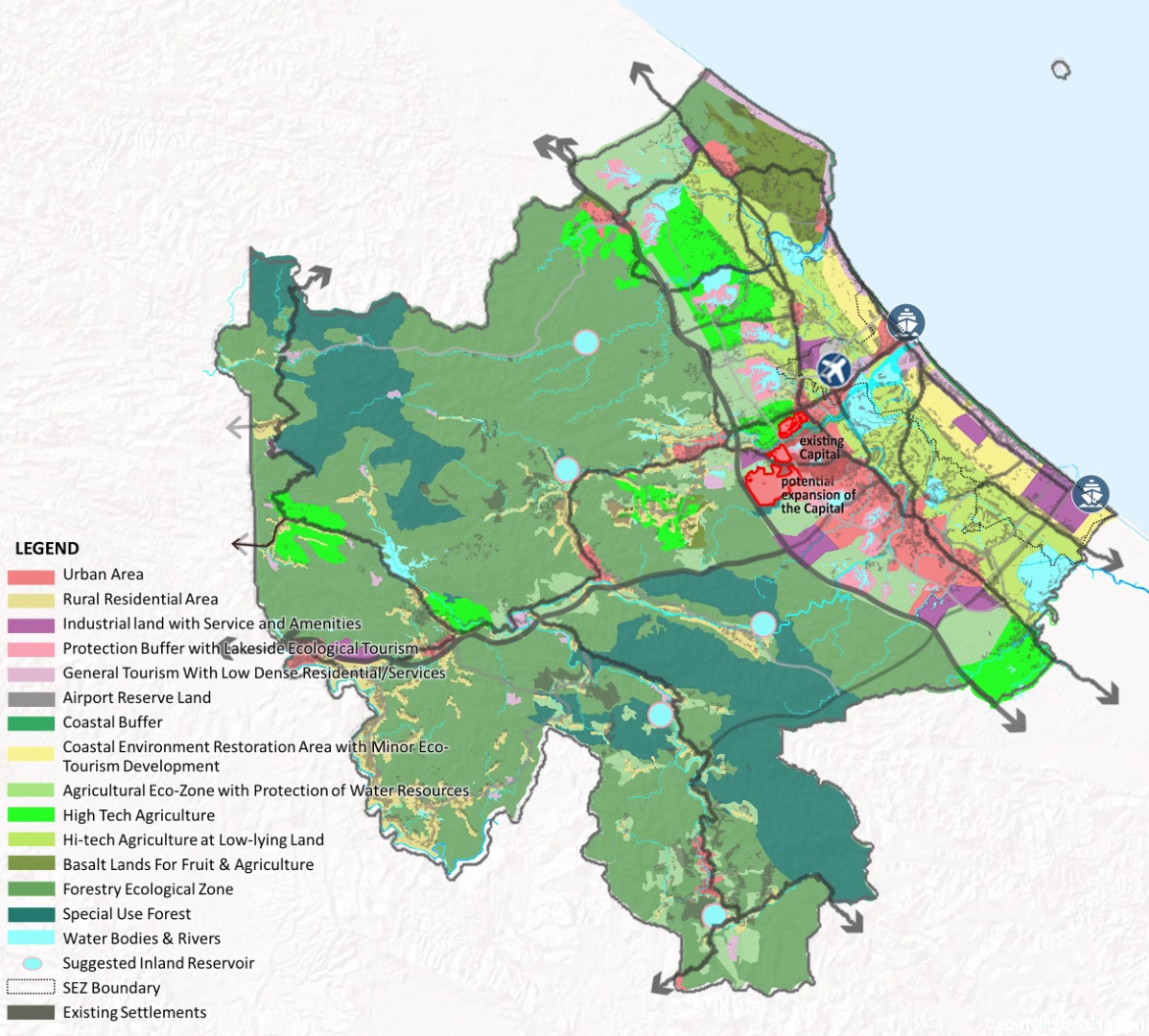
To determine suitable land for urban and agricultural development, a base mapping exercise was carried out. The base map used high resolution satellite images as the primary base and overlaid multiple layers of data received including Natural Constraints, Environmentally Sensitive areas and Human Intervention & Commitments.
02 QT Land Developability Study Maps Large
Quang Tri Land Developability Study Maps
Integrating all three layers/ categories above, it was determined 31.1% of the province or about 1,498 sqkm, was suitable for future development.
03 QT Land Developability Distribution Chart Large
quang tri land distribution percentage
Quang Tri Land Developability Distribution Chart
20 1 QT Land Use Development from Base Map to Year X base map 1440
Quang Tri Constraints and Commitment and Vacant Developable Land Map

KEY STRATEGIES AND PLANS

The CMP encompasses 6 main strategies for development: Water Management, Coastal Protection, Agricultural Development, Industrial Development, Tourism Development and Social Inclusion.

Water management

Due to its vulnerability to floods and other natural disasters, the CMP adopted a comprehensive and integrated approach in proposing mitigation strategies. The three-pronged strategy involves: Western reservoirs and dams, retention lakes in lowlands and flood zones, and dykes and barrages.
LAYER 1: WESTERN RESERVOIRS/ DAMS in upstream areas in west mountainous areas to reduce water flow towards the flood plains during wet season. The reservoirs also act as a water source for drinking water, a potential source of hydro-driven energy source, and a driver of eco-tourism.
LAYER 2: RETENTION LAKES IN LOW LAND & FLOOD ZONE focuses on expanding existing retention lakes and create new large retention lakes (possibly 300 ha to 500 ha) in the flood zone to protect surrounding land from flooding and to store water for irrigation combats droughts. Soil removed in retention creation could be used to level up the low-lying land platform.
LAYER 3: DYKES AND BARRAGES: Dykes (earthwork or engineered) to above 100 years flood level (in areas where coast level was lower than 100-year flood level) eliminates sea water intrusion to the fertile plains, protect agriculture land & infrastructure and ensured a secured life for the people.
05 QT Overall Strategies And Structure Map For Flood Mitigation 1440

Quang Tri Overall Strategies And Structure Map For Flood Mitigation

Coastal Protection

QT boasts a 75km coastal belt with beautiful beaches, though large portion of it was subjected to serious damages from current and climate change. Along areas with coast higher than 100-year flood level, the CMP proposed 3 methods of protection based on the allowable land use were proposed: coastal revetment or green buffer, a cascading step planter and a hybrid mangrove revetment. This aims to protect the coastal area from floods and disasters without compromising on the goal of coastal preservation.
06 Coastal Revetment Section at Industrial Development Area Large
Coastal Revetment Section at Industrial Development Area
07 Cascade Step Planter Section in between Industrial and Eco Large
Cascade Step Planter Section in between Industrial And Eco Tourism Zone / Hybrid Zone
08 Hybrid Mangrove Revetment Section at River Mouth Large
Hybrid Mangrove Revetment Section at River Mouth
To ensure clarity, a chart was formulated to facilitate understanding of the recommendations, strategies in terms of environmental sustainability goals for the master plan.
09 Overall Summary Chart for Flood Mitigation and Coastal Protection Strategies Large
Overall Summary Chart for Flood Mitigation and Coastal Protection Strategies

Agricultural Development

As the food basket of the region in this region of Vietnam, agriculture (especially rice planting) is one of the major economic activities in QT, with rice planted mostly in the flood plains. Farmers are working at the mercy of the weather and a looming threat of sea water intrusion destroying the land. Water management strategies, when implemented would ensure better control for the farmers, enabling more secure income and better life.
Beyond rice planting, the CMP took advantage of QT advantages including availability of fertile land, water and long agriculture tradition to propose 3 types agriculture land strategy with the following goals: transition from a traditional agriculture economy to a high-tech agriculture economy, increase productivity and yield with less reliance on manpower and introduce resilient agriculture to minimise impact from climate change.
10 Proposed Agricultural Development Zones In QT 1440
Proposed Agricultural Development Zones In Quang Tri
The strategy can be divided into 3 approaches: 1) at the flood plains, utilising technology and high-yield seeds to increase yield, 2) establishment of high-tech farms at higher ground with good accessibility to transport, water and housing, and 3) planting of high-value crops and providing training and R & D facilities.

Industrial Development

The QT government aims to industrialise and leverage the benefits of the emerging digital economy. The plans consist of consolidating industrial parks, situating them away from flood zones and closer to developed urban areas and key infrastructural and transport nodes for easy access and increased connectivity.
Key industrial parks include those around the airport, Lao Bao Economic Zone, at key transport gateways and regional hubs.
11 Proposed Industrial Land for 2030 and 2050 In QT Large
Proposed Industrial Land for 2030 and 2050 In Quang Tri

Tourism Development

With diverse ecology, rich history and a unique cultural landscape, QT boasts an emerging tourist destination. To capitalise on its strengths, the CMP must gear development towards attracting higher value tourism and increasing tourists’ duration of stay.
The CMP tourism plan includes preserving existing cultural and historical sites, as well as adding new attractions to bolster tourism around natural splendours and cultural sites alike. Additionally, the CMP recommended that QT works with Hue province and Danang to market collectively a curated program of “Ancient tour of Hue1 , War history of Quang Tri and modern entertainment of Danang”.
12 Proposed and Existing Tourism Nodes In QT Large
Proposed and Existing Tourism Nodes In Quang Tri

Social Inclusiveness

Rural population (as much as 50% of the existing population) in QT faces significant challenges in terms of access to essential services and job opportunities. Low income, lack of opportunities and low standard of living led to brain drain to major cities including Hanoi, HCMC and Danang.
To address these issues, the CMP proposed to integrate social inclusiveness with economic development. By doing so, QT could improve the quality of life for its residents and energise its economy at the same time, driving prosperity and liveability for the region.
13 Major Rural Hubs Rural Areas In QT Large
Major Rural Hubs & Rural Areas In Quang Tri
On top of physical improvement, the CMP also proposed gradual investment in essential infrastructure, ensure access to education, stabilising land usage, improving agriculture, injecting new types of economic activities and upskilling and training programs in the short to mid-term.

CONCEPT MASTERPLAN

14 QT Development Concepts Growth Axis Large
Quang Tri Development Concepts & Growth Axis

Urban expansion

Encompassing the aspirations of the people and the local government, the Year X Visionary MP is made to fit the economic projection and the goal of QT’s development: transforming QT into a “Plentiful Province”. Tailored to the availability of the land and its socioeconomic conditions, the MPs – both the 2030 CMP and 2050 Actual MP – are drafted to be balanced and sustainable. Development along the various growth axes will increase connectivity and safeguard the land from disasters. The concept MP strife to create a balanced & sustainable plan with One North-South Axis and Two Northern East-West Axis of Urban and Economic development corridor, and Two safeguarded corridor for flooding mitigation and coastal protection.
15 QT Land Use Plan Land Distribution By Year X 1440
Quang Tri Land Use Plan & Land Distribution By Year X
After expansion, the western dry land would be the new capital city of QT. Other than My Thuy Seaport and committed industrial developments along the coast, the rest of the planned industrial parks will be consolidated and moved back to dry land near urban centres.
Two natural constraint zones (west mountains and flood plains) and a coastal protection corridor were identified and will be safeguarded. Developments within these zones and corridor are controlled with recommended guidelines. Secondary urban hubs within the flood plains were carefully identified and would be protected by dykes if necessary. When possible, new developments in these hubs would be on higher grounds filled with soil from retention lakes creation.

Transportation

The CMP ensured a well-connected province, within and to other provinces. The transport network of roads, air and sea (and reservation) were planned to satisfy future needs.
Land – Enhanced connection was planned between economic nodes, urban and rural centres facilities. Connection to the other provinces, national roads are enhanced and the upcoming HSR was realigned along the NS expressway corridor to avoid cutting through the province.
Air – An approved new airport was planned to be operational in the next 5 years which would enhance air connection to the rest of Vietnam and the region.
Water transport – Rivers with navigational potential were identified.
03 Expansion of the capital Large
Proposed Transportation Upgrades & Alignment Masterplan for Quang Tri (Year 2050)
An example of cost-effective vital infrastructure investment integrated with other economic benefits is the National Highway No.9 (NH9). Identified as a vital economic link between Vietnam and the surrounding nations, an expansion of the highway entails increased connectivity and potential for development.
17 NH9 Highway Alignment Large
NH9 Highway Alignment
19 Proposed Road Adjustment Expansion Scenarios On Different Condition Large
Proposed road adjustment and expansion scenarios in different conditions

OVERALL IMPACT TO THE PROVINCE

The CMP addressed the challenges and took advantages of opportunities presented to improve the livelihood and quality of life of its citizens while preserving the environment and mitigating disaster risks. Implemented, it aims to steer QT towards our goal of a “Plentiful Province” with a Vietnamese model of inclusive and sustainable growth, resilient and secure environment, over the next 30 years.
Seed image
Quang Tri’s Land Use Development from Base Map to Year X
The SEEDS Journal, started by the architectural teams across the Surbana Jurong Group in Feb 2021, is a platform for sharing their perspectives on all things architectural. SEEDS epitomises the desire of the Surbana Jurong Group to Enrich, Engage, Discover and Share ideas among the Group’s architects in 40 countries, covering North Asia, ASEAN, Middle East, Australia and New Zealand, the Pacific region, the United States and Canada.
Articles at a glance

pop up banner